Labels

holiday (104) overseas (101) australia (97) victoria (90) 4wd (83) friends (56) europe (53) food (49) history (48) camping (46) river (45) southeast asia (44) sculpture (34) church (29) bird (28) temple (26) market (25) angkor wat (20) restaurant (19) train (19) lake (18) art (17) drink (17) high country (17) vietnam (17) wildlife (17) castle (15) fountain (15) hiking (15) France (14) Italy (14) Roman (14) boat (14) united kingdom (14) bridge (13) flower (13) monk (12) queensland (12) waterfall (12) England (11) cat (11) fishing (11) mine (11) roadtrip (11) ruin (11) culture (10) dog (10) palace (10) snow (10) burma (9) cave (9) garden (9) laos (9) medieval (9) music (9) cambodia (8) lizard (8) london (8) mountain (8) myanmar (8) New Zealand (7) North Island (7) alpine national park (7) buddha (7) busker (7) desert (7) goat (7) handcrafts (7) mallee (7) museum (7) snake (7) toolangi state forest (7) water buffalo (7) Germany (6) Uzes (6) huts (6) owl (6) Austria (5) Bavaria (5) Garmisch (5) Rome (5) Switzerland (5) big river state forest (5) children (5) plane (5) sunset (5) war (5) Barcelona (4) Florence (4) Lake Como (4) Paris (4) Salzburg (4) Spain (4) aboriginal (4) art gallery (4) cathedral ranges (4) craigs hut (4) duck (4) ha long bay (4) harry potter (4) horse (4) mekong (4) nsw (4) tudor (4) tunnel (4) volcano (4) wallaby (4) Annecy (3) Carcassone (3) Edinburgh (3) Ludwig (3) Maori (3) Montmartre (3) Scotland (3) Sound of Music (3) Sun King (3) Taupo (3) Venice (3) beach (3) bunyip state forest (3) elephant (3) furnicular (3) geocaching (3) geyser (3) goulburn river (3) inle lake (3) kangaroo (3) luang prabang (3) mitchell river (3) mt terrible (3) murrindindi state forest (3) otways (3) pig (3) relic (3) saigon (3) sheep (3) thailand (3) vientiane (3) wombat (3) wombat state forest (3) yangon (3) Bath (2) Bay of Islands (2) Cotswolds (2) Grindelwald (2) Ta Prom (2) Warrumbungles (2) amelie (2) cairns (2) carnavon gorge (2) cow (2) crooked river (2) dance (2) eagle (2) eildon state forest (2) enoch point (2) fish (2) flowers (2) goanna (2) ha noi (2) ho chi minh (2) hue (2) jamieson river (2) latrobe river (2) macaron (2) marysville (2) monkey (2) pakse (2) puppet (2) snowy river (2) upper yarra reservoir (2) warburton state forest (2) Auckland (1) Banteay Kdei (1) Baphuon (1) Bayon (1) Cambridge (1) Canterbury (1) Eastern Mebon (1) Hobbiton (1) Liechtenstein (1) Louis (1) Mt Ruapehu (1) Phimeanakas (1) Pre Rup (1) Preah Khan (1) Rotorua (1) Tonle Sap (1) Vatican (1) Waitangi (1) airshow (1) architecture (1) bagan (1) bangalore (1) bangkok (1) barrier reef (1) bear (1) beechworth (1) burger (1) cabaret (1) cat ba island (1) cattle (1) cemetery (1) coffee (1) craft (1) dingo (1) echidna (1) emu (1) festival (1) frog (1) gliders (1) glow worm (1) gold (1) grampians (1) gypsy (1) hoi an (1) india (1) jet boat (1) king river (1) kinglake (1) koala (1) leeches (1) linga (1) mandalay (1) marble (1) massage (1) mekong delta (1) military (1) mossman gorge (1) mynamar (1) mysore (1) ninh binh (1) nun (1) ocean (1) possum (1) purple citadel (1) rainforest (1) rangoon (1) rubber (1) rubicon state forest (1) scam (1) scone (1) sheepyard flats (1) siem reap (1) tiger (1) werribee gorge (1)
Showing posts with label craigs hut. Show all posts

Saturday, 6 November 2004

Craigs Hut

Participants: Nidhi, Sampath, Pavan, Bhaskar, Suresh, Praveen & Mark


We departed from the city pretty much on plan; everybody being picked up and on our way about 8:00am with beautiful clear blue skies. We took the more scenic route as opposed to the fastest route, driving out via Healesville where we stopped for some last minute supplies and then winding our way across the Black Spur. The plan was to stop in Fernshaw for morning tea, but for some reason the place was locked up so went to Plan B and stopped at Dom Dom Saddle.
The instant we were out of the car we were greeted by a Magpie with his young chick, both very keen for food, and both also very adept at catching any food thrown at them.
We drove out through Eildon and climbed up and along Skyline Road, which offered some scenic views back into the Goulburn Valley as well as across over Lake Eildon which was much higher than my previous recent trips. We spotted a couple of Wedgetailed Eagles soaring over the ridge top and pulled over at a lookout to get some photos of the views across the lake.


The road then took us down to the lakeside where we got caught up behind some cyclists. We pulled over to take some more photos as the views were very scenic with the water so high and the clouds rolling across the valley; so far the rain forecasted had held off.


We stopped in at Mansfield and the bad weather chasing us from Melbourne finally caught up. It briefly hailed and then cleared up again as we drove out of Mansfield towards Mt. Buller.
We headed up towards Mt Stirling, passing a cyclist who had an extremely long and arduous climb ahead of him! Off to the right we had some views of Mt Buller, which still had some snow cover. Pavan had not previously seen snow so we were hopeful of coming across some today.


We drove down to Pineapple Flat on the King River, and the river was noticably higher and faster flowing than it had been on my previous visits. A quick chat with some people parked on the bank indicated that some other cars had recently crossed so we drove in and through the river, with water coming up over the bonnet we made it to the otherside where we setup for lunch.
The rain held off long enough for us to setup the tarp and picnic, and came down quite heavily as we sat under the tarp enjoying our lunches.


Soon after lunch the clouds cleared away again and we went for a short walk along the King River, with numerous wild flowers in bloom and the sun shining again.
The original plan for this trip was to drive along King Basin Track and up the Staircase to Mt Speculation and Lake Cobbler, but since the river was higher than normal and the rain had been falling heavily I decided against the 10 or so river crossings and the likely slippery Staircase climb that path would take us on. Additionally, Pavan hadn't seen snow before so I expected that going up to Craig's Hut would give us the highest probability of seeing some snow falling.


We drove out across King River again, and a few more times as well to get some good photos and then headed up to Mt Clear to visit Craigs Hut.


We arrived at Craig's Hut with the most beautiful views across the mountains with large fluffy white clouds rolling across the sky. There was a light dusting of snow as well, so Pavan received his wish!


We spent about 10 minutes enjoying the views and taking photos when almost instantly the views vanished as the mountain clouded over. An icy wind picked up and a light snow began falling. We sheltered in Craig's Hut from the wind and snow, enjoying the warm fire that was a new edition from our last visit.


The snow soon stopped falling and a lovely rainbow appeared near Mt Speculation.


A large group of trailbike riders arrived at the hut just as we were leaving and followed us as we continued on towards The Monument. We drove down Monument Track, which was very rocky in some places, and much rougher than my previous visit.


We stopped off at Bindaree Falls which was in good flow and then drove down to Bindaree Hut for afternoon tea.


We had a nice hot chocolate which was very welcome and warming before our long (very long) trip back home.
We drove along Upper Howqua Track then climbed out of the Howqua Valley along 16 Mile Jeep Track. This was reasonably steep and wet, though we made it out without any problems. We even spotted a few wallabies along the way.
Corn Hill Logging Road which climbs up to Mt Buller looks like a quicker exit from here but I'd like to check it out under drier conditions. It is marked as Management Only on the CFA maps though looking now on the Parks Website it is a seasonal closure track, and requires a crossing of the Howqua River as well as a steep climb with a number of switchbacks. Still, it's one to keep in mind for future trips.
So we continued up Bluff Link Road and out of the Valley at Refrigerator Gap where the mobiles were all working again. A few calls back to those waiting for us in Melbourne before heading out of the bush along Bluff Link Road, Brocks Road and then through Sheepyard Flat. On through Mansfield and Yea, we caught sight of the city lights past Whittlesea and had everybody dropped off home before 10:30PM.


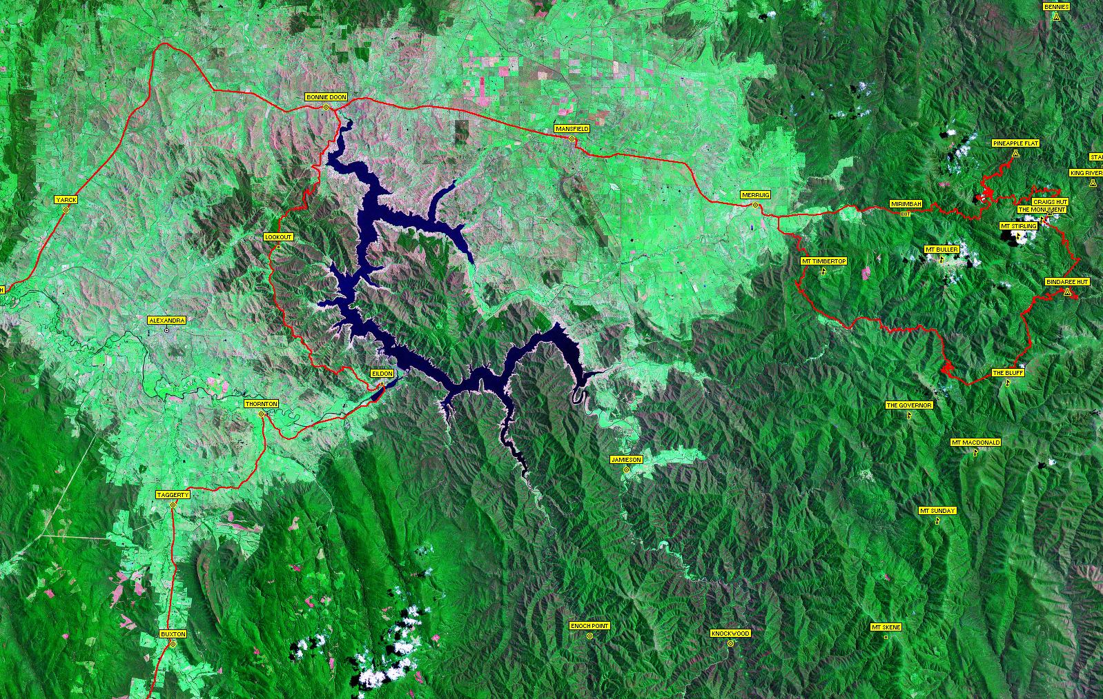
Click here to see a satellite image of our travels. Note, large image(563KB).

Track Summary & Travel Times

Track NameSurfaceTravel TimeTotal DistanceAvg SpeedMin AltMax Alt
Healesville to EildonHighway1 hour 15 minutes80km64km/hr97 metres524 metres
Eildon to Bonnie Doon (Taylors Road)2WD Gravel, beautiful views over Lake Eildon1 hour 2 minutes39km38km/hr234 metres651 metres
Mansfield to Pineapple FlatHighway/4WD Easy - Deep river crossing of King River1 hour 38 minutes58km36km/hr331 metres1351 metres
Pineapple Flat to Craig's Hut4WD Easy51 minutes33.9km40km/hr668 metres1462 metres
Craig's Hut to Monument Track4WD Easy8 minutes1km7km/hr1458 metres1472 metres
Monument Track4WD Medium/Hard(Wet) Moderate descents, loose rocks and rock ledges16 minutes3.6km13km/hr1341 metres1534 metres
Bindaree Hut to Bluff Link Rd (Upper Howqua Rd/16 Mile Jeep Track)4WD Medium - some steep sections35 minutes16.3km28km/hr786 metres1288 metres
Bluff Link Rd to Sheepyard Flat2WD Gravel44 minutes32.2km44km/hr557 metres1297 metres
Howqua Track (from Sheepyard Flat)2WD Gravel20 minutes16.8km50km/hr513 metres576 metres

Saturday, 17 January 2004

Craig's Hut - King River Day Trip

Participants:

Mark, Pius, Smitha, Praveen and Suresh

Smitha taking a photo with Maroondah Reservoir in the background
This was the first of what I hope will be many trips into the Victorian Bush for our Bangalore team mates as they come out to visit Australia.
Pius was kind enough to round everybody else up and bring them to my place, from where we began our journey shortly after 9:00am.  We headed out past Healesville, and had the first of many smoko stops for Suresh at Selover's Lookout, looking over Maroondah Reservoir.  The weather wasn't looking good, but we were hopeful it would clear up by the time we reached the High Country.

Winding through the Black Spur
We continued through the Black Spur, winding amongst the lush Tree Ferns and Victorian Mountain Ash.  The Ash is the tallest tree in Australia, which can reach heights of 100 metres.
The road proved too slippery for one car, which had run off the road down the embankment just before St. Ronan's Well.

Recovering the Troupie which had rolled down the embankment
We had to wait half an hour or so whilst the car was retrieved.  A little bit of excitement for the trip!  The planned stop at St. Ronan's Well to sample the mountain spring water was given a miss, since the traffic built up from the blocking of the road would have kept us delayed much longer still.

Suresh, Praveen and Pius near Goulburn Valley
On the move again and we stopped near the Archeron Cutting for a quick morning tea, to enjoy the views of the Goulburn Valley, and to give Suresh a smoko.
After passing through Alexandra, we moved off the highway onto a shortcut to Bonnie Doon which took some time off the journey, as well as taking us through some scenic, if dry farmland.  Coming around a corner over a small bridge there was a snake lying across the road.  It appeared dead, and there was no chance to stop or swerve to avoid it, but on reversing back to see if it was Ok or not, it was nowhere to be seen.
Back on the main road towards Bonnie Doon we spotted three Wedge Tailed Eagles soaring over the road.

Sheep Herding near Merrijig
After passing through Mansfield we came across a farmer herding his sheep with a quadbike and two sheep dogs.  I asked the guys if they used dogs to round the sheep and goats up back in India.  Praveen said it was much cheaper to have a human round them up then to train a dog!

Climbing Mt Stirling from Howqua Gap
We turned off the sealed road just before Mt Buller at Merimbah and started heading up the mountains.  We passed Telephone Box Junction, with it's many cross country skiing trails now being walking trails during the summer.
We continued along Circuit Road and almost missed the turnoff at Howqua Gap.  Changing down into real 4WD, we started our ascent of Mt Stirling.  The road was in very good condition having been recently graded by its appearance.  Still it was a real taste of off-road, especially as we crawled over the many cross-cut drains and through a couple of tight switchbacks.
The track levelled off amongst the Snow Gums, which was a perfect place to stop, stretch the legs and spines and take some photos.

Praveen, Pius, myself and SmithaRest stop by the Snow Gums on Mt Stirling
Watchful cows
We spotted some cattle left to graze through the bush, but they moved off to a safe distance as Suresh approached.  The cows in Australia aren't quite as friendly as the cows back in India.
Bidding the cows farewell, we were back in the car to make our way to Mt Stirling summit.

Smitha, Pius, Suresh and Praveen on the summit of Mt Stirling
A short climb brought us to the peak, which had panoramic views across the High Country and back to Mt. Buller, where Suresh and Praveen had both visited on a previous trip during the snow season.

Pius enjoying the 'on top of the world' feeling
There was a crisp breeze, so it was jacket time for most but the weather was starting to fine up nicely.  We passed a father and his young son who were hiking across the hills as we continued on to Craig's Hut.

'Those aren't real graves are they?'
The views from Craig's Hut are always fantastic, and even the cloudy day couldn't spoil them.  We explored around the hut, and were almost able to convince Suresh that the graves were real.

Smitha, Pius, Praveen and Suresh at Craig's HutEnjoying the view but not the flies

Lunch at Craig's Hut
After exploring the hut, it was time for lunch before backtracking a little to The Monument, a peak half way between Craig's Hut and Mt Stirling.  We made our descent off the mountain down Monument Track, which wound down fairly steeply in some parts, passing over some rocky shelves along the way.
We drove down to Bindaree Falls, where the bridge over Bindaree River was out. We drove down the ravine and through the creek to the other side of the bridge and made our way up the walking  track to the falls.

Crossing Bindaree RiverBindaree Falls

Group shot beneath Bindaree Falls
The walking track passed under the falls allowing a scenic view through the cascade and past the tree ferns back down the river valley.  We were soon back into the car and making our way towards King Hut. 

Suresh enjoying one of the many river crossings
Another bridge was unsafe to cross, so we took the small ford alongside it; a photo opportunity Suresh couldn't miss.

Cows relaxing at King Hut
Not too much longer and we arrived at King Hut.  Can you believe it, more cows!  We put the Billy up to boil, and made our way down to the river.  Suresh slipped on one of the cobblestones and got a foot wet, but most unfortunately I missed the photo.  We enjoyed the cool water and the serene location by the river for a while, and then returned to the hut for our afternoon tea break.

Smitha on King RiverSuresh cooling off in King River

Coffee by the Hut
After coffee and Oreo's, we drove along King River Basin, crossing the river some 6 times before arriving at Pineapple Flat camping area.  The river was quite low, barely coming up to the steps on the car with the crossing into Pineapple Flat being the deepest.  A couple of kids fishing by the river crossing probably didn't appreciate our arrival!
More leg stretching and exploring along the river to help break up our drive.  A number of people where camped here, it truly is a popular camping spot.  We crossed the river again on our way out, with the kids still fishing beside the river crossing.

Our track blocked by a fallen gum tree
We thought we were on our way back out of the forest heading home, only to come around a bend in the track to see a gum tree fallen and blocking the way out.

We made it through!
After attacking the tree with an axe, a drag chain, a winch and the muscle power of 4 guys, 20 minutes later we eventually cleared enough of the tree off the track to get through.  The rest of the trip off the mountain into Mansfield was thankfully uneventful.  We stopped at Flakeout in Mansfield for dinner and spent another two hours on the road, arriving home at my place at 10:30 in the evening.  I didn't envy the rest of them who had another 45 minutes or so of travel back to their respective homes!  A long but enjoyable day.

Saturday, 16 March 2002

Craig's Hut Day Trip

Participants:

Adriana, Oiyee:   

Honda CRV

Fot, Marisol, Jacqui and Stephen: 

Honda CRV

Beryl & Kurt: 

Toyota Surf

Mark, Michelle, James, Liam, Glenda & Arthur:

Nissan Patrol

We all met at my place in Eltham, did introductions and soon made our departure about 9:30.  We drove out through Yarra Glen and up the Melba through Yea and stopped for a Morning Tea and biscuits at Bonnie Doon.  We continued on towards Mt Buller, turning off at Mirimbah towards Telephone Box Junction.  The road was getting pretty rough, so I stopped to let some air out of the tyres, which works wonders in creating a smooth ride on the rough roads.

After a quick toilet stop at Telephone Box Junction, we made our way on towards Circuit Road.  At some point along the road we found an extensive growth of Blackberries, so we all pulled over and had a feast.  We were soon on our way again and headed up Clear Hills Track, which was in fine condition and posed no problems for the CRVs.


After exploring the hut and taking in the views, we sat beneath the tress near the car park for our picnic lunch.  Whilst we were eating, a wedding arrived, complete with Bride & Groom on horseback and drizabones, and even a Scottish bag piper!
We planned to drive up to Mt Stirling, but the road soon became too rough for the CRVs, so it was back down the way we came and we then continued along Circuit Road.  I drove down a side track to see if I could find King Hut, but I hadn't been there before, and I had no real indication how far we had to travel so I gave up and came back to the others who had waited at the turn off.
We were headed towards Bindaree, when Adriana had a blowout on her rear tyre.  A group on horse back we were passing called it into us on the UHF.  After much hunting around to find out where the jack was stored on these CRVs, we had the tyre changed and were on the move again.
The last part of the track was too rough for the CRVs, so we parked them and ferried everybody across the Howqua to Bindaree Hut in the Patrol and Surf.
It was starting to get fairly late at this stage, so after our explore of the hut, a warm cuppa, and a splash in the river for the kids we made our way back to Circuit Road and into Mansfield for Fish & Chips, and our long drive back home.

Monday, 5 November 2001

Sheepyard Flats

Camping trip to Sheepyard Flats

Mark, Michelle, James & Liam
Henric & Annaleigh

Saturday

We setup camp at near Pickering's Hut in Sheepyard Flat by the Howqua River.  Yet again there was a multitude of horses along with their riders camping here as well.
River Crossing - Bindaree Hut
We drove up Brock's Road, and from memory drove along 16 Mile Jeep Track, passing some magnificent camp sites along the Upper Howqua.  We crossed the upper reaches of the Howqua and continued on to Bindaree Hut, another magnificent hut and camping area.  We crossed the shallow Howqua after enjoying lunch by the hut and made our way along Bindaree Road, Summit Road and made the steep rocky ascent up Summit Track to Mt Stirling.

Mt Stirling
There was reasonable patches of snow on Stirling, which the kids quite enjoyed playing in.  The views were magnificent, except of course of Buller, which looks pretty sad with the ski runs cut through it.  We continued down Summit Track, onto Clear Hills Track and soon arrived at Craig's Hut, being our first visit.  If we thought the views from Mt Stirling were great, the views from Craig's Hut were magnificent.

Craig's Hut
We continued down Clear Hills Track onto Circuit Road and made our way back to our camp at Sheepyard Flat.  Henric and I went off exploring looking for firewood, and managed to bring back a reasonable supply, only to find that the girls already had the campfire going.  We had an enjoyable dinner followed by some pretty damn good damper with Golden Syrup.

James & Liam playing with fire, again...

Sunday

After the obligatory bacon and eggs breakfast, we drove down to Tobacco Flat, which had some nice camp spots and wasn't as crowded as Sheepyard.  The river crossing looked passable, and others had gone through but we weren't quite up to it today.

Exploring the Slate Mine
We continued up the steep narrow climb out of the valley, and drove along Mitchell's Track to the Slate Mine, and enjoyed the views for short stop.  Mitchell's Track eventually made a sharp decent, though recently regarded to Mitchell's Homestead.  We couldn't explore around here too much as there was a group camping there so we found a quite place beside the river and had our lunch.  We made our way back to camp via Wrens Flat and the Jamieson-Licola Road.

Monday

Monday was a relaxing morning packing up the camp.  We managed to spot a Koala in the campsite on the way out of Sheepyard Flats and we took it easy on the way back home.